The growing demand for precision in dredging and construction has pushed project teams toward digital guidance and real-time positioning systems that reduce guesswork and improve control. RTK GPS plays a key role in this shift by providing highly accurate location data that helps operators follow design depths, slopes, and alignments with confidence. With better accuracy and fewer errors, teams experience reduced rework, smoother workflows, and more consistent operational performance across both land-based and marine environments.
Understanding RTK GPS
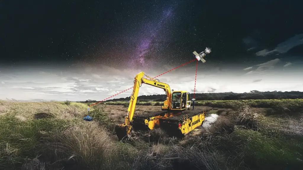
RTK GPS is a positioning method that provides construction and dredging equipment with a clear, highly accurate reference for location. By correcting normal satellite errors, RTK helps operators follow design depths and grades with greater confidence, especially when working underwater or in low-visibility conditions.
What RTK Technology Does
RTK uses two receivers to achieve accuracy that standard GPS cannot reach.
- A base station remains fixed and constantly calculates satellite errors
- A rover is mounted on the machine and receives correction data from the base
- The corrected signal gives the operator a true position with centimeter-level accuracy
This helps excavators, dredgers, dozers, and graders to follow digital models without depending on visual cues, which is especially important underwater.
Standard GPS vs RTK Accuracy
The accuracy of standard GPS is usually within one to three meters. That inaccuracy is reduced to a few centimetres via RTK. This distinction has a direct impact on:
- Depth control in dredging
- Slope shaping for banks and shorelines
- Trenching and foundation alignment
- Material quantities and rework rates
For heavy civil and marine work, these stricter accuracy controls cost and reduce operational risk.

Why Positional Certainty Matters
In dredging and various construction tasks, the operator cannot see the attachment. RTK becomes the only reliable reference for:
- Cutting to the correct depth
- Maintaining stable slopes
- Avoiding damage to structures or liners
- Minimizing overexcavation that increases fuel and labor costs
Regular location tracking minimises the need for divers or repetitive survey inspections while helping teams comply with environmental constraints.
Key Advantages of RTK GPS
RTK brings clear performance improvements to both marine and land-based operations.
Precision benefits:
- Centimeter-level horizontal and vertical accuracy
- Controlled excavation and grading
- Cleaner passes with fewer corrections
Operational stability:
- Reliable tracking even when the equipment is submerged
- Less dependence on visual markers or survey stakes
Productivity gains:
- Real-time feedback to the operator
- Faster cycle times and fewer unnecessary movements
- More predictable production output
Components of an RTK Integrated System
To give operators a precise view of their machine position, RTK guidance uses a combination of hardware and software. Each element contributes to the conversion of satellite data into practical, real-time guidance for building and dredging operations.
Hardware
A complete RTK setup typically includes several essential components.
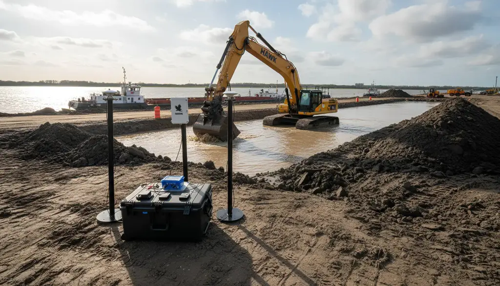
- Base station and correction signal: The base station remains fixed at a known point and broadcasts correction data to the machine, enabling centimeter-level accuracy under challenging field conditions.
- Rover antennas mounted on equipment: These antennas receive corrected positioning data and track the machine as it moves across a site or within a dredging footprint.
- Boom, stick, bucket, and hull angle sensors: These sensors measure the exact orientation of the attachment or dredging ladder, enabling the system to calculate the true tool-tip position underwater or on land.
- Heave, roll, and pitch sensors for floating platforms: Marine equipment is constantly subjected to wave motion, so motion sensors help stabilize position output and maintain accurate depth control.
- Rugged on-board displays for real-time visualization: Operators view the live cut, grade, or depth information on a durable screen designed for harsh jobsite environments.
Software
The software side connects design data with real-time machine feedback.
- Guidance platforms for construction and marine machinery: These systems convert RTK signals into simple graphics that help operators follow the planned design surface.
- Integration with survey data, dredge templates, and CAD models: The machine always operates at the correct depth, slope, and alignment because digital models are entered directly.
- Automated production reporting and logging: All movements are tracked for QA, compliance, and productivity monitoring, enabling precise project tracking and billing.
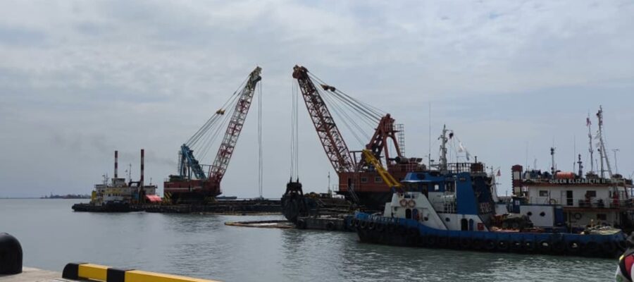
RTK Integration in Dredging
Since most work is done underwater, where operators have restricted sight, RTK GPS is particularly useful for optimising dredging equipment. Dredging teams reduce overexcavation and environmental disruption while maintaining precision by integrating location data with hydrographic instruments and angle sensors.
Excavator-Based Dredging
RTK improves the accuracy and efficiency of excavator dredging on barges, shorelines, and amphibious platforms.
- How geometry sensors track bucket tip location: Sensors measure the angles of the boom, stick, and bucket to calculate the exact position of the bucket tip beneath the waterline.
- Maintaining design depth and slope underwater: Operators see live guidance on the display, allowing them to cut to the correct depth and maintain smooth slopes without repeated survey checks.
- Improving control of amphibious excavators and long-reach systems: RTK stabilizes navigation on soft ground or in floating conditions, giving the operator greater control in areas that are usually difficult to measure.
Cutter Suction and Clamshell Dredgers
RTK positioning also enhances accuracy for larger assets, by dredging equipment.
- RTK positioning combined with ladder and boom sensors: The system calculates the exact position of the cutter head or clamshell bucket as it moves through the dredge area.
- Precision layer cutting for contaminated or sensitive sediments: Controlled depth guidance helps remove only the required material, protecting clean layers and improving environmental compliance.
- Minimizing environmental impact through controlled excavation: Better accuracy reduces turbidity, unnecessary cuts, and overall disturbance to the surrounding ecosystem.
Real Time Hydrographic Integration
Linking RTK with hydrographic systems gives continuous insight into dredging progress.
- Synchronizing RTK with sonar or echosounder data: Depth readings and position data combine to create a live map of the underwater surface.
- Updating bed levels during operations: Operators receive immediate feedback on how each pass changes the seabed, improving production efficiency.
- Producing as-dredged surfaces for QA and payment certification: Logged data can be exported into reports, ensuring that project owners, regulators, and contractors have clear documentation of the completed work.
RTK Integration in Construction Equipment
Since most work is done underwater, where operators have restricted sight, RTK GPS is particularly useful for optimising dredging equipment. Dredging teams reduce overexcavation and environmental disruption while maintaining precision by integrating location data with hydrographic instruments and angle sensors.
Dozers and Graders
RTK guidance helps these machines complete grading and earthwork with far fewer corrections.
- Blade control guided by digital terrain models: The system displays the blade position relative to the design surface, helping operators maintain the right grade from the first cut.
- Faster embankment shaping and pad construction: With clear visual guidance, dozers and graders build pads, berms, and access roads in fewer passes and with less trial and error.
- Reduced need for survey stakes and layout teams: The digital model replaces physical markers, accelerating work and reducing interruptions from re-staking.
Excavators
RTK improves control and visibility for excavators working on land or near the shoreline.
- Precise trenching and foundation work: Operator uniformity in trench and footing excavations is improved by having them follow depth and alignment goals immediately on the screen.
- Creating a slope to defend the shoreline: Levees, embankments, and erosion-control structures can be built on regulated slopes because of their precise placement.
- Improved cut-and-fill volume control: Regular depth monitoring improves material estimates for project planning and minimises overexcavation.
Marine Structure Installation
Projects involving piles, caissons, or pipelines benefit from RTK because alignment accuracy is essential for long-term stability.
- Positioning piles, pipes, and caissons with precise alignment: The system guides placement both horizontally and vertically, keeping each structure in its correct position.
- Reduced rework due to higher placement accuracy: Fewer corrections are required, which saves time and minimizes delays across the installation sequence.

Operational Benefits
By increasing efficiency, reducing costs, and enhancing project compliance, RTK GPS delivers clear benefits to dredging and construction equipment teams. These advantages immediately yield more reliable field results and more efficient operations.
Increased Productivity
- Faster cycles with continuous feedback: Operators adjust their movements instantly in response to real-time guidance, reducing unnecessary passes.
- Reduced operator guesswork: Clear on-screen visuals replace manual judgment, improving consistency across shifts and operators.
- Improved production planning: Logged data supports accurate scheduling, cycle tracking, and day-to-day planning.
Cost and Material Control
- Prevention of over-dredging and excessive excavation: Precise depth control reduces wasted time, fuel, and material removal.
- Accurate tracking of pay quantities: Production data is recorded automatically, supporting transparent and fair billing.
- Lower fuel and operating hours through efficient cuts: Fewer corrections and cleaner passes reduce machine wear and overall project costs.
Safety Improvements
- Reduced need for diver intervention: Accurate digital guidance limits the need for underwater inspections.
- Controlled excavation reduces the risk of slope failures: Following design slopes more closely helps maintain site stability.
- Better visibility in low-visibility or underwater conditions: Operators rely on digital feedback instead of sight alone, improving safety in challenging environments.
Environmental and Regulatory Compliance
- Precision removal in sensitive ecosystems: RTK helps avoid unnecessary disturbance and protects clean sediment layers.
- Improved turbidity and sediment disturbance control: Controlled excavation techniques lead to cleaner, more compliant operations.
Data Traceability and Reporting
- Automatic logging of production data: Every cut and movement is recorded for project documentation.
- Clear documentation for clients and regulators: Reports generated from RTK data simplify approvals and compliance checks.
- Transparent quality assurance workflows: Teams can verify that work matches the design surface and environmental requirements.
Performance Considerations and Limitations
Although RTK GPS greatly improves accuracy in dredging and construction, there are practical limits that teams must consider when planning field operations.
- RTK range limits between base and rover: To ensure centimetre precision, the rover must stay within a tolerable range of the base station. Reliability can degrade, and adjustments can weaken over long distances.
- Vertical accuracy challenges in marine environments: Water movement, vessel motion, and tidal variations make vertical positioning more difficult than horizontal positioning, requiring additional sensors and proper calibration.
- Signal loss due to structures, cranes, or canopy: Tall equipment, bridges, and dense overhead cover can interrupt satellite signals, reducing availability in busy ports or confined construction sites.
- Importance of stable communication channels: RTK corrections depend on a consistent radio or network link. Any drop in communication can cause delays or temporary accuracy loss.
Best Practices for Implementation
Successful RTK integration requires careful planning and ongoing quality control to ensure accurate results throughout the project lifecycle.
- Detailed calibration of boom, stick, bucket, and ladder geometry: Proper calibration ensures the system calculates tool position correctly, especially for excavators and ladder-based dredges.
- Routine quality control checks: Regularly verify that sensors, antennas, and reference points remain aligned and functioning correctly.
- Operator training for interpretation of guidance screens: A Clear understanding of the visual display helps operators use the system effectively and avoid misinterpretation in challenging areas.
- Backup positioning and redundancy during critical operations: Dual antennas, motion sensors, or alternative reference points provide support when conditions affect signal stability.
- Integrating positional data with survey and project control workflows: Sharing RTK data with planners and survey teams improves coordination, documentation, and overall project management.
Future Developments
The importance of RTK in dredging and construction applications continues to grow with advances in positioning and automation.
- Growth of low-cost multi-GNSS systems: Smaller contractors and remote projects can now achieve high-precision location thanks to more cost-effective receivers that track multiple satellite constellations.
- Integration with semi-autonomous dredging platforms: Emerging equipment designs use RTK guidance to enable automated movement, maintain consistent depth control, and reduce operator workload.
- Use of AI for production optimization: AI tools are increasingly analyzing RTK data to suggest more efficient digging paths, cycle improvements, and fuel-saving strategies.
- Adoption of digital twins for planning and monitoring: By feeding digital twin models with real-time RTK data, project teams can make better decisions by having a real-time, accurate view of site conditions.
Conclusion: Upgrading Precision in Modern Dredging and Construction
RTK GPS has become a key tool for improving accuracy and reliability across dredging and land-based construction. Providing operators with real-time positional awareness reduces uncertainty, strengthens depth and grade control, and minimizes costly rework. With clearer guidance and automated reporting, teams can deliver cleaner cuts, follow design intent more consistently, and maintain higher productivity throughout the project.
For organizations ready to enhance precision and overall field performance, partnering with a reliable equipment provider makes a meaningful difference. At Pump Enterprise, we support projects like ours with advanced pumping and dredging solutions that complement RTK-guided operations, enabling us to execute work more efficiently, safely, and with greater confidence.
Related Posts
Post a Comment